In the beginning
you pass by amazing Black Oak and Madrone trees typical of the Sierra Nevada
Yellow Pine Belt composed of trees like the platy Ponderosa pine, furrow-feeling
Douglas-fir, slightly smelly Incense Cedar, and smooth-barked Madrone. Eventually
you work your way to a lush creek valley about half way, which is good place
to rest and drink some freshly filtered water. Beyond this stop you will find
excellent vista points overlooking the granite valley which merges into the
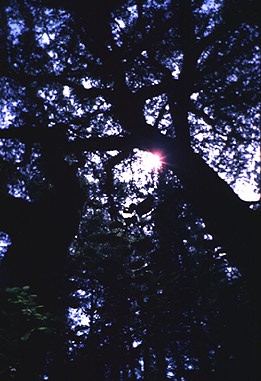
Middle Fork of the Feather River at a distance. Much of the trail is shaded
as you work your way along the eastern edge of Fall River Canyon to your left.
Once you see, smell and hear the falls ahead, split to the left toward the viewing
platform or to the right to stand next to the plunge. Beyond the falls is a
good place to camp for overnight backpackers and the trail continues for miles
past the falls for the more adventurous explorer. If you have never been here,
definitely check out this place because this is a popular, fun hike. Mountain
bikes are allowed too.
Update: Two (2) trails
now exist: an easier, less strenous one that meanders for about 4.5 miles and
the original, shorter version about 3.4 miles to the famous falls. I also understand
it is wheelchair accessible, albiet in need of a helping hand in rough spots.
Best Parts: setting,
vegetation and overlooks
Directions: To reach
Feather Falls is fairly easy to do if you can spy the road signs along the route
past Oroville. First get to Oroville, CA. Off Highway 70 take the "Oro-Dam Boulevard"
exit and drive a few miles to the "Olive Hwy." After cruising for a few minutes
along this strip mall boulevard the majority of traffic turns right onto Olive
Hwy. Continue about 6 miles to "Forbestown Road" posted on the right with a
large green sign indicating "Feather Falls - 18 miles" this way. In about another
6 miles "Lumpkin Road" appears on the left side of the road. This is your route,
so continue on this windy road for about 10 miles or so until you see a sign
for Feather Falls. Keep your eyes open too because the turn-off sign can be
hard to see.
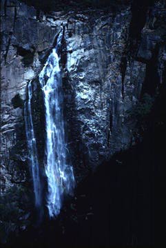 Known
as the sixth largest waterfall in the United States, Feather Falls cascades
over 640 feet to the canyon below. The hike is a little over 3 miles or a couple
hours from the trailhead, which seems like a quick hike on your way back, but
it can be a long and tiring walk on your way in with a moderate elevation gain
(1,100 feet). You will probably keep asking "are we there yet." Once you reach
your destination, there is an excellent viewing platform across from the falls
among the lush setting and rock exposures. I feel like I am in the high Andes
of Peru (although I have never been to Peru). Here is a map
of where Feather Falls is located.
Known
as the sixth largest waterfall in the United States, Feather Falls cascades
over 640 feet to the canyon below. The hike is a little over 3 miles or a couple
hours from the trailhead, which seems like a quick hike on your way back, but
it can be a long and tiring walk on your way in with a moderate elevation gain
(1,100 feet). You will probably keep asking "are we there yet." Once you reach
your destination, there is an excellent viewing platform across from the falls
among the lush setting and rock exposures. I feel like I am in the high Andes
of Peru (although I have never been to Peru). Here is a map
of where Feather Falls is located.