 While
many options exists for exploring Lassen Volcanic National Park, I will focus
on three popular hiking and backpacking routes: Lassen Peak, Summit Lake, and
Drakesbad Guest Ranch.
While
many options exists for exploring Lassen Volcanic National Park, I will focus
on three popular hiking and backpacking routes: Lassen Peak, Summit Lake, and
Drakesbad Guest Ranch.While
many options exists for exploring Lassen Volcanic National Park, I will focus
on three popular hiking and backpacking routes: Lassen Peak, Summit Lake, and
Drakesbad Guest Ranch.
Contents: |
Peak | Summit Lake | Drakesbad
| Camping & Information | Map
|
The
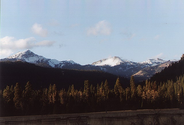
Peak - For a day hike and a wonderful panoramic view of the Sacramento
Valley, Lake Almanor to the east, Mt. Shasta to the north and the surrounding
wilderness for miles, many people hike to the top of (10,457') Lassen Peak.
While this sounds high in elevation, you start your hike at about 8,000 feet
and then take many switch backs to the top. This trail is likely to be crowded
with all sorts of people, young and old on a fair-weather day. Anyone can make
it to the top with a little "will-power" and fortitude. It is about 2 1/2 miles
to the summit (which is less than a two hours hike for most people). I once
heard a father telling his struggling son that if he kept up the hard work,
soon he would buy him a Coke and a hot dog at the hot dog stand once they reached
the top. Needless to say, there is no hot dog stand at the top of Mt. Lassen,
but I'm sure the son enjoyed the lofty view. The rewards of reaching the top
is well worth the effort.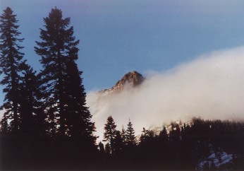
Directions: Simply take Highway 89 through the park winding your way up the mountain. At about 8,000 feet lies a large parking lot, probably with many cars, which marks the spot.
Summit Lake - This is a nice backpacking loop for the weekend or longer. It is also a fairly flat, easy hike offering numerous shallow lakes and a distinctive volcanic landscape. I spent the night at Rainbow Lake, only a couple of hours hike in. The following day we hiked across an open pumice landscape to the Cinder Cone, an excellent example of this type of volcano. To reach the top of the Cinder Cone takes awhile (even though it is only 750 feet high) because of the loose cinder trail. Once you reach the top, however, you are in for a surprise. From the top you can see the Painted Dunes, a motley group of earthly pastels and recent lava flows. You can also see larger lakes like Juniper and Snag Lake. Another destination is to Snag Lake or Horseshoe Lake, nestled in the hearty forest of Lodge Pole Pine, White Fir, and Jeffrey Pine. Bring a swim suit and fishing pole because these numerous lakes are a refreshing site. Summit Lake North and South Campgrounds are at the trailhead.
Directions: Take Highway 89 through the park until you reach the marked campgrounds.
Best Part: unique geology, solitude & quietness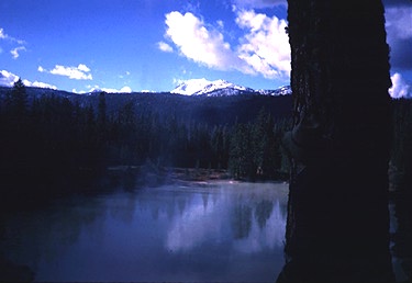
Drakesbad Guest Ranch - A sizzling place to see geothermal activity is Devil's Kitchen, accessible via Drakesbad. This area is visited less frequently by tourist than those who see Bumpass Hell hotsprings area off Hwy 89, and in my opinion, this area has more variety too. To see Devil's Kitchen, which is about 1 hour from the trailhead, travel through the meadow beyond Drakesbad Guest Ranch until you reach the forest. You gradually climb for a short while, then reach Park Service boardwalks and hear funny sounding mud pots--"blub... blub." This area is mostly enclosed by wooden fences to keep curious people from the boiling water, fragile crusts, and sinking soils. Be extremely careful. The man who named Bumpass Hell, incidentally, plunged into boiling hotsprings and lost his leg as a result. Once you have taken in the steam here, head back down the trail until you branch off the main trail toward Boiling Springs Lake (in photo above). This lake's water temperature is well over 100 degrees and has a strange tawny, vitriolic appearance. Continue down the trail to Terminal Geyser, which is nothing like Old Faithful but interesting enough to see. I kept warm there during the cool weather. You can also backpack here, but this is more typically a day hike (about 6.2 miles round trip). Warner Valley Campground is nearby.
Best Part: geothermal activity, solitude, mellow hiking
Directions: From Chester, CA (off Highway 36), take Feather River Drive on the West side of Chester's main drag (that's before you hit the old center of town). There should be signs pointing you toward Drakesbad Guest Ranch as well and check your odometer because it is about 17 miles to the end of the road. Follow this paved road which soon bears to the left and eventually turns to dirt. In about 6 1/2 miles the road splits again; veer right this time onto Warner Valley road. In short, follow the most traveled road.
Lassen Volcanic National Park
P.O. Box 100
Mineral, CA 96063-0100
(916) 595-4444
Campgrounds: seven campgrounds on a first-come first-serve basis (no reservations). Fee charged.
Wilderness Permit: Required for overnight use and obtained at any contact point or headquarters. Can write or call for them. No wood fires allowed.
[ Home | Index | Photo Gallery ]