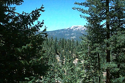
 You
can see the south part of the Yolla Bolly Wilderness and its tallest peak, Mt.
Linn (8092 feet), from Interstate 5 near Corning, CA. Mt. Linn is the centerpiece
of the "Ides Cove Trail," and it lies right in the middle of this 8 miles loop
trail. Within 100 feet of the trailhead you can either go left (as the "trail"
sign indicates) or right (which is really straight and heading roughly northwest).
Trail destinations, such as Long Lake, are not marked. We chose the left path
because the sign led us this way. But we soon discovered this route is the long
(and some might say the wrong) way around Mt. Linn because it jogs along the
south-facing exposures and offers nothing really spectacular to see until you
reach the backside. If we had taken the right path, we would have reached Long
Lake in little more than an hour and a mere 3 miles from the trailhead, which
is probably one of the best camping spots in this area.
You
can see the south part of the Yolla Bolly Wilderness and its tallest peak, Mt.
Linn (8092 feet), from Interstate 5 near Corning, CA. Mt. Linn is the centerpiece
of the "Ides Cove Trail," and it lies right in the middle of this 8 miles loop
trail. Within 100 feet of the trailhead you can either go left (as the "trail"
sign indicates) or right (which is really straight and heading roughly northwest).
Trail destinations, such as Long Lake, are not marked. We chose the left path
because the sign led us this way. But we soon discovered this route is the long
(and some might say the wrong) way around Mt. Linn because it jogs along the
south-facing exposures and offers nothing really spectacular to see until you
reach the backside. If we had taken the right path, we would have reached Long
Lake in little more than an hour and a mere 3 miles from the trailhead, which
is probably one of the best camping spots in this area.
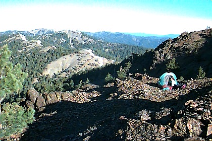
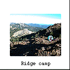
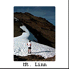
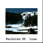 We
saved the best scenery for last, however, as we hiked about 4 miles that day
before climbing switchbacks on the backside of Mt. Linn. By the time we ran
out of energy that afternoon, the only level spot along the trail was this craggy
hill, so we camped on rocks that evening. But in the morning we enjoyed spectacular
views of the vast coastal range rolling all the way toward the ocean. We also
saw a route to the top of Mt. Linn and groovy patterns along the ridge lines.
After breakfast we worked our way through a dense stand of Douglas-fir and White-fir
and down toward Long Lake. This section of the trail was particularly scenic
as we admired the distant views of the Trinity Alps. Along the way we heard
snow melting beneath our feet and water cascading down the slope, such as in
this open meadow.
We
saved the best scenery for last, however, as we hiked about 4 miles that day
before climbing switchbacks on the backside of Mt. Linn. By the time we ran
out of energy that afternoon, the only level spot along the trail was this craggy
hill, so we camped on rocks that evening. But in the morning we enjoyed spectacular
views of the vast coastal range rolling all the way toward the ocean. We also
saw a route to the top of Mt. Linn and groovy patterns along the ridge lines.
After breakfast we worked our way through a dense stand of Douglas-fir and White-fir
and down toward Long Lake. This section of the trail was particularly scenic
as we admired the distant views of the Trinity Alps. Along the way we heard
snow melting beneath our feet and water cascading down the slope, such as in
this open meadow.
 As
we returned toward the trailhead, we could now see Mt. Shasta and the Sacramento
Valley floor; eventually Mt. Lassen popped into view. With a warm feeling in
my heart, I started to feel as if this trip wasn't so bad after all, even with
the snow-pack navigation and rocky exposures. The South Yolla Bolly Wilderness
certainly had something well worth offering us--solitude--lot's of it, and beautiful
distant views of northern California's glistening peaks.
As
we returned toward the trailhead, we could now see Mt. Shasta and the Sacramento
Valley floor; eventually Mt. Lassen popped into view. With a warm feeling in
my heart, I started to feel as if this trip wasn't so bad after all, even with
the snow-pack navigation and rocky exposures. The South Yolla Bolly Wilderness
certainly had something well worth offering us--solitude--lot's of it, and beautiful
distant views of northern California's glistening peaks.
Best parts: solitude,
distant views, rocks, snow-scape in June
Directions - From Interstate
5 turn off onto highway A-9 at Corning, CA and head west toward Paskenta, a small
hamlet at the base of the coastal range about 20 miles away. As you approach Paskenta,
don't cross Thomes Creek but instead veer right onto a country road (called Road
M2 at some point). This road will take you initially north for a few miles then
head up a grade. Follow M2 road from Paskenta for about 20 miles until it turns
to dirt. Eventually you reach a remote CDF hub called Cold Springs Fire Station.
At this point veer onto Forest Service Road M22. Now it is about 8 miles more
to the S. Yolla Bolly turn-off, where you turn left (west) for another 2 miles.
Proceed up the hill to the Ides Cove Trailhead (if they have cleared the fallen
tree in the midst of all that messy "slash." Otherwise you will have to walk about
1/4 mile to the trailhead.)
Important Information:
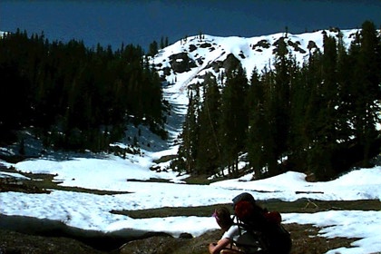
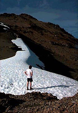
 This
isolated trailhead presents some unexpected challenges. First of all you must
travel over logging roads with ugly clear-cuts along the way for about 35 miles.
This is easy enough with a two-wheel drive vehicle and high clearance. But then
you have to deal with snow heaped on the trail if you arrive too early in June
like we did. As you look around the low-elevation landscape (around 6000 feet)
you wouldn't expect snow here. In addition, the Yolla Bolly Wilderness lies
in a rainshadow where most of the precipitation falls toward the coast. We encountered
so much snow, particularly on the north-facing trails, that we had to navigate
our way by notches cut in the trees. We would have lost our way otherwise, so
attempt this trail only in mid to late June.
This
isolated trailhead presents some unexpected challenges. First of all you must
travel over logging roads with ugly clear-cuts along the way for about 35 miles.
This is easy enough with a two-wheel drive vehicle and high clearance. But then
you have to deal with snow heaped on the trail if you arrive too early in June
like we did. As you look around the low-elevation landscape (around 6000 feet)
you wouldn't expect snow here. In addition, the Yolla Bolly Wilderness lies
in a rainshadow where most of the precipitation falls toward the coast. We encountered
so much snow, particularly on the north-facing trails, that we had to navigate
our way by notches cut in the trees. We would have lost our way otherwise, so
attempt this trail only in mid to late June.