|
Beneath the Flood
by Joyce Tokita and Jamie Cameron-Harley
During rainy Sacramento Valley winters, the Yolo Bypass is a sight to behold. If you’ve ever driven along Interstate 80 over the bypass, all you see is water that stretches to the horizon. It’s no wonder that the valley was once called "an inland sea."
The bypass’s history and role in flood control traces back to a time when floodwaters often inundated much of the Sacramento Valley. The settlers tried in vain to contain raging floodwaters between levee systems, but frequently the dirt embankments were overtopped or breached, and homes and farmlands were flooded.
The situation worsened with the advent of hydraulic mining, with debris clogging river channels and limiting their capacity to carry water. More and more devastating floods occurred. But even with the demise of hydraulic mining operations, the situation remained grave.
Soon a new attitude began to emerge, one that acknowledged, during floods, the river needed more room.
In the early 1930s a flood management system was built by the U.S. Army Corps of Engineers that recognized the river’s needs. The system included bypasses, areas set aside to carry or bypass excess floodflows, relieving the pressure on levees along the main river channels.The system now comprises the Sacramento River Flood Control Project.
As part of the project, the Yolo Bypass serves a vital role in protecting river cities such as Sacramento from winter and spring floods. But the bypass is more than an extra channel to carry excess floodflows to San Francisco Bay. Beneath the floodwaters’ surface lies another world just recently explored.
Floodwater Habitat
“The basin is totally unappreciated,” says Environmental Specialist Ted Sommer, who became interested in studying the bypass after finding a lack of research linking the floodplain to the estuary. “It’s a different place when there is water in it.”
In 1995–a very wet year–Sommer, with other DWR and DFG staff, began sampling and studying fish found in the bypass, focusing on chinook salmon and other native species.
What they found was the bypass served as a seasonal aquatic habitat for at least 40 fish species, including listed ones such as the delta smelt, steelhead trout, and spring-run and winter-run chinook salmon. Results also showed that habitat and fish diversity are higher in the floodplain than in the adjacent Sacramento River.
“The bypass is an especially important spawning grounds for split- tail,” says Sommer. Study findings show that the splittail, listed as threatened under the federal Endangered Species Act, move into the basin in winter and early spring to forage and spawn on flooded vegetation. Their young stay in the bypass until the floodwaters begin to recede.
Sommer also discovered that young chinook salmon were using the Yolo Bypass as a migration corridor instead of the mainstem Sacramento River. The basin offers extensive rearing habitat– vegetation along the shoreline and broad shoals, favored by the young salmon.
Several of the study’s results show that young salmon grow much faster in the Yolo Bypass floodplain than in the Sacramento River. The difference is likely due to the warmer waters of the bypass which also offer a more ample supply of insects to feed on.
The bypass however does have risks for the inhabiting fish as flows fluctuate in the basin. Fish can be stranded as the flows recede from the basin, although Sommer found that the majority successfully emigrate from the floodplain.
Sommer’s bypass studies received an initial grant from CALFED for $225,000 in 1996. “That was the shot in the arm we needed to get started,” he says.
A second CALFED grant in 2000 will enable DWR staff–working with a team of environmental groups, engineers, and biologists–to discover the full potential the bypass holds for fish and wildlife habitat. Study results will contribute to a long-term strategy to manage the habitat while maintaining the bypass’s use for flood control and agriculture. Results will also contribute toward the ecosystem restoration of the Sacramento San Joaquin Delta and in turn a long-term fix for the troubled estuary.
“We are just beginning to learn how the bypass benefits fish and wildlife,” Sommer explains. “The bypass is a ‘gold mine’ of information, right in our own backyard.”
How The Bypass Works
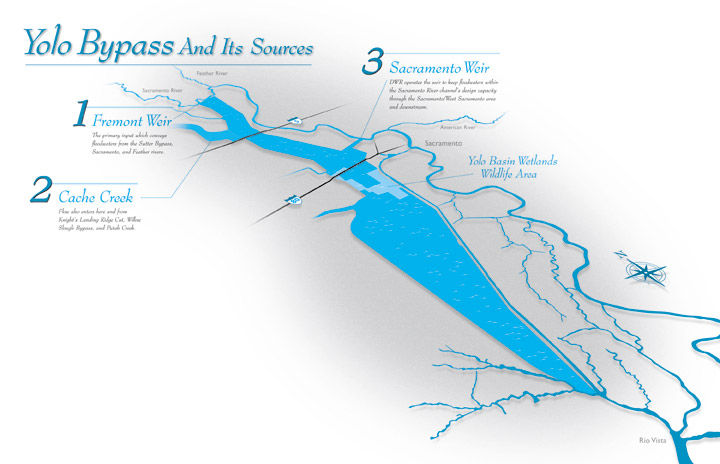
The Yolo Bypass is one of two primary bypass systems constructed in the Sacramento Valley (the other being Sutter). Excess floodwaters enter the bypass from the main river channel. This relieves pressure on the main levee system along the river channel and helps keep flows within the channel’s design capacity.
This 3-mile wide, 40-mile long stretch of land extends from the confluence of the Feather and Sacramento rivers to a point above the city of Rio Vista, where it safely returns the excess flows to the Sacramento River. Water primarily enters the basin through the Fremont Weir in the north. The weir also allows inflows from the Sutter Bypass and the Feather and Sacramento rivers.
Water can also enter from the east via the Sacramento Weir, adding additional flows from the American and Sacramento rivers. From the west side, the basin receives water from Knights Landing Ridge Cut, Cache Creek, Willow Slough Bypass, and Putah Creek.
In more than half of all water years (from October l to September 30), the bypass is inundated, creating up to 60,000 acres of shallow water habitat. When completely flooded, the Yolo Bypass about doubles the wetted area of the Sacramento-San Joaquin Delta, covering an area equal to about one-third the size of San Francisco and San Pablo bays.
Water depths range from 10 feet in a heavy water year to around 6 feet in a normal year. During spring (as late as June), water in the basin empties through a riparian channel that borders the eastern edge of the Yolo Bypass called
the “Toe Drain.”
“Because the land has
been graded for agricultural use, the bypass drains relatively well,” says Pete Rabbon, General Manager of the State Reclamation Board. “Over the years, the bypass has done its job well and has prevented much property loss and saved lives for many of the communities along the Sacramento River system.”
The Board, along with DWR, is responsible for maintaining the flood carrying capacity of the basin. The labor of keeping the Yolo Bypass (as well as the Sutter Bypass and Tisdale, Colusa and Moulton weirs) clear falls to DWR’s Sacramento and Sutter Maintenance yards, while the Board, created in 1911 as part of the Central Valley’s flood control plan, oversees its operations as part of the Sacramento and San Joaquin Drainage District. The Board also owns easements that allow the bypass to be flooded.
Other Floodplain Benefits
When dry, the bypass area’s rich clay loam soils provide fertile cropland for tomatoes, safflower, sugar beets, rice, corn, and other grains. The land is privately owned.
The Yolo Bypass is also a place that wildlife enthusiasts and birders enjoy. Once a thriving wetland, the region and its marshy habitat supported an array of wildlife and birds. Then shortly after the Gold Rush, settlers began reclaiming the land and draining what was considered swamplands. In the process, much of the natural habitat was lost.
But thanks to a partnership between State (including DWR and the State Reclamation Board) and federal agencies, along with local conservation groups, a piece of the Yolo Bypass has been restored as a new state wildlife area. In 1991 the California Wildlife Conservation Board purchased 3,600 acres, now known as the Vic Fazio Yolo Wildlife Area.
The Corps of Engineers planned the habitat restoration and completed the on-site work, since the wildlife area will
still serve as part of the Sacramento River Flood Control System. The altered landscape is now graced with grasslands, seasonal and permanent wetlands, and riparian woodland. Each habitat type was designed to be compatible with its primary function, flood control.
“The wildlife area will also help reverse a 20-year decline of bird populations that migrate along the Pacific Flyway,” says David Feliz, the Yolo Bypass Wildlife Area Manager for the Department of Fish and Game, Region 2. “It will provide a vital resting and feeding spot for thousands of shorebirds and waterfowl along the migration corridor.”
Illustration of the Yolo Bypass.
A Vision Too Bold
In 1870, General B. S. Alexander of the Army Corps of Engineers firmly believed that the waters of the Sacramento River had to be held within a single channel. This was based on a theory that it would increase its flood-bearing capacity so it could carry all flows into the delta without overflowing.
But Will Green, editor of the Colusa Sun, adamantly disagreed. Although he had limited formal education, Green knew this was impossible after watching the Sacramento River from the town of Colusa for about 10 years. Alexander’s theory was based on experience along the Mississippi River, a waterway whose floodwaters built slowly, unlike the Sacramento River, whose devastating flows struck swiftly.
Green’s vision was a system of weirs and basins into which the river could pass its excess flows. These flows would be contained in canals to allow the lowlands outside these channels to be occupied. During dry times, the holding basins could be farmed.
It wasn’t until 1920 that the Corps turned around its flood control philosophy to embrace what Green envisioned 50 years earlier.
|