Geography
85
Applications on GeoSpatial Technology
Introduction to GPS - Part II
More advanced units not only store location but also can inventory geographic feature attributes and their values.
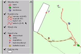
example, if you were to inventory the Sierra College cross-country track & nature trail system, you would want to walk the track & trail system to capture location of the paths. But you would also want to observe characteristics about that trail system, such as the width of the path, what is the condition of the path, what is the surface, etc.
These characteristics are called "attributes," and each attribute will have specific "values." For example, the attribute known as width could be given values such as: narrow (1-2'), wide (2-4'), road (4'-8), and wide road (8-16').
Creating a Data Dictionary
You must formalized this inventory process by way of creating a "data dictionary." Then you input it into the computer and upload it to the GPS unit. This is done with software, but you must think about at least three (3) things before you open the software:
- What are the geographic features that you want to collect?
- What do you want to know about these geographic features, their attributes?
- What are going to be those values?
As the example above illustrates, you must think about it in three parts, and you must think about all of the geographic features you will want to locate and collect data about in the process. Certainly you would want to collect more features than roads & trails, like structures, stray trails, signs, parking areas, bridges, culverts, etc. And then there will be some features you discover on the way, such as power pole lines (a good base map reference point) or a small amphitheater area, or an erosion event, or a downed tree, all of which would be useful to manage the trail system. Thus you probably should scout out the area first before you invest too much time developing a formal data dictionary.
Often it is a good idea to conduct a pilot project. In this case you would create and load a sample data dictionary into the GPS unit, go into the field to see if it works, and then revise the data dictionary back at home (or in the field with a laptop computer). I've found this process takes several tries to get it right. To start creating a data dictionary, I often write it out first.
In this draft rendition, you will see in the table the features culverts, signs, and gates. I further break this down to the material, the length, the diameter as an attribute. Futhermore, each attribute has a value, such as concrete (culvert), metal, plastic, etc. For signs, I have type and condition. For gates, I have type, id, and condition with select values, such as green gate.
Here's the example:
Feature |
Attribute |
Values |
Comments |
culverts |
material |
concrete |
drainage of trails |
|
|
metal |
|
|
|
plastic |
|
|
length |
varies in feet |
number 1 - 100' |
|
|
e.g. 12' |
|
|
diameter |
to 1' |
range between |
|
|
1-2' |
|
|
|
2-3' |
|
|
|
3-4' |
|
signs |
type |
directional |
|
|
|
regulatory |
|
|
|
informational |
|
|
|
entry |
|
|
|
other |
put in comments |
|
condition |
excellent |
|
|
|
fair |
|
|
|
poor |
needs replacement |
gates |
type |
wooden |
|
|
|
powder_river |
green gate |
|
|
other_metal |
|
|
|
aluminum |
|
|
id_number |
varies |
whatever tag says |
|
condition |
excellent |
|
|
|
fair |
|
|
|
poor |
needs replacement |
This is just a partial list, and notice that I used exact text for the attributes and values. That's why I used underscores ("_") between words, because this is the exact spelling and length of the text entered into the computer and GPS unit. Computers care about exact spelling.
Comments don't matter as much as they won't be used for GIS queries or analysis.
Once entered into the computer, the data dictionary is uploaded into the GPS unit and you’re ready to go. Even after all these years -- this is the basic process today.
More to Read (It is on the quiz too)
- Next go to > GPS Steps and Protocol
- And then read “MROSD GPS/GIS Pilot Project ..."