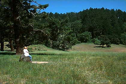
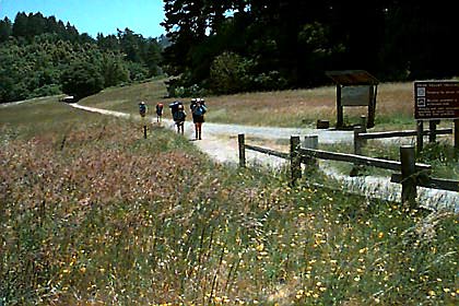
 We
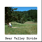
began our overnight backpacking trip at the popular Bear Valley Trailhead and
headed toward Glen Camp about 4.6 miles away (one of four backcountry camps)
. The trail is wide and level with only a slight slope until you reach what
I call the Bear Valley Divide. From this midway point the trail and creek slope
downhill toward the ocean. Occasionally we came across beautiful open meadows
like this one at the "divide," which incidentally is a fine resting spot with
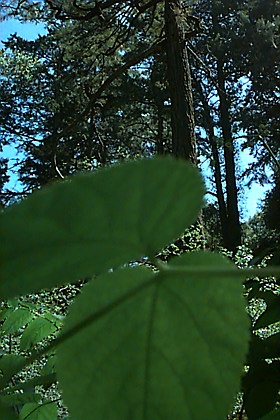
restrooms. Much of the trail is shaded by lush deciduous trees and towering
Douglas fir and Bishop pine along the hillsides. You will also find most of
the people on this trail.
We
began our overnight backpacking trip at the popular Bear Valley Trailhead and
headed toward Glen Camp about 4.6 miles away (one of four backcountry camps)
. The trail is wide and level with only a slight slope until you reach what
I call the Bear Valley Divide. From this midway point the trail and creek slope
downhill toward the ocean. Occasionally we came across beautiful open meadows
like this one at the "divide," which incidentally is a fine resting spot with
restrooms. Much of the trail is shaded by lush deciduous trees and towering
Douglas fir and Bishop pine along the hillsides. You will also find most of
the people on this trail.
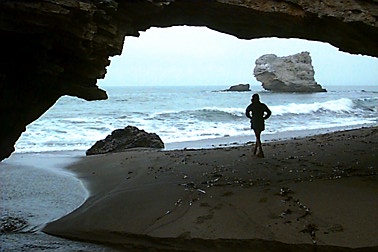
 The
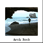
following day we trudged through tall grasses, stinging nettles, scrappy chaparral,
and ate blackberries along the way. Meandering toward the ocean we discovered
colorful wildflowers and hardy succulents blooming near the ocean bluffs. Upon
arriving at Arch Rock, we couldn't find the "arch" until we looked closely beneath
us. Two people passed below us and out onto the beach; hence we discovered the
arch was directly beneath us. This arch is typical of northern California's
coastline, known as a emergent coastline, where the coastline is actually rising
faster than the sea level.
Relentless wave action then
batters and carves away this newly rising land, leaving erosional features such
as sea caves, sea stacks and arches like this one shown.
The
following day we trudged through tall grasses, stinging nettles, scrappy chaparral,
and ate blackberries along the way. Meandering toward the ocean we discovered
colorful wildflowers and hardy succulents blooming near the ocean bluffs. Upon
arriving at Arch Rock, we couldn't find the "arch" until we looked closely beneath
us. Two people passed below us and out onto the beach; hence we discovered the
arch was directly beneath us. This arch is typical of northern California's
coastline, known as a emergent coastline, where the coastline is actually rising
faster than the sea level.
Relentless wave action then
batters and carves away this newly rising land, leaving erosional features such
as sea caves, sea stacks and arches like this one shown.
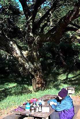
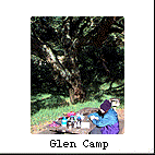 We
spent most of our time inland because I knew how the summer brings chilly morning
fog and strong afternoon wind. I was also eager to explore the varied landscape
of Point Reyes and a different camp. Previously I stayed at Coast Camp and found
its open setting unappealing, especially when a troop of Boy Scouts started
screaming "skunk" as one ran through their camp. We opted for Glen Camp this
time in the gentle hills with trees and protection from the ocean breeze. This
camp was quiet, with only 3 campers on this weekday, but I didn't like the camp
arrangement because it is located in a giant meadow with everyone facing one
another. The Park Service even put a camp in the middle of the meadow as a joke
so everyone can stare at them. Quite frankly, I consider this type of backpacking
similar to car camping with designated campsites, picnic tables, toilets, trash
cans, grills (even though wood fires are prohibited), food boxes and running
water. We found no skunks at this camp, but a mighty mouse managed to break
into our food box and eat our oatmeal. Watch it because these Pt. Reyes animals
are domesticated and will nibble right through your wooden food box. While I
am talking about hazards, much of the terrain is covered with poison oak, stinging
nettles and ticks. My favorite part of Glen Camp is a majestic Coast Live Oak
that drapes itself over someone's lucky campsite.
We
spent most of our time inland because I knew how the summer brings chilly morning
fog and strong afternoon wind. I was also eager to explore the varied landscape
of Point Reyes and a different camp. Previously I stayed at Coast Camp and found
its open setting unappealing, especially when a troop of Boy Scouts started
screaming "skunk" as one ran through their camp. We opted for Glen Camp this
time in the gentle hills with trees and protection from the ocean breeze. This
camp was quiet, with only 3 campers on this weekday, but I didn't like the camp
arrangement because it is located in a giant meadow with everyone facing one
another. The Park Service even put a camp in the middle of the meadow as a joke
so everyone can stare at them. Quite frankly, I consider this type of backpacking
similar to car camping with designated campsites, picnic tables, toilets, trash
cans, grills (even though wood fires are prohibited), food boxes and running
water. We found no skunks at this camp, but a mighty mouse managed to break
into our food box and eat our oatmeal. Watch it because these Pt. Reyes animals
are domesticated and will nibble right through your wooden food box. While I
am talking about hazards, much of the terrain is covered with poison oak, stinging
nettles and ticks. My favorite part of Glen Camp is a majestic Coast Live Oak
that drapes itself over someone's lucky campsite.
 Point
Reyes is more than beautiful scenery and unruly animals though. It is about
geology and what happens deep beneath the Earth's surface. If you look at Point
Reyes on a map it looks geographically funny with its elongated Tomales Bay
and fluted coastal points. Stranger yet, its parent rocks match that of the
Tehachapi Mountains, more than 310 miles to the south. What's going on here?
Here's a clue... earthquakes frequently occur here. You guessed it--the San
Andreas Fault runs right through Point Reyes. Incidentally, California is not
falling into the Pacific Ocean as illustrated here. Rather, part of California
is sliding along this transverse fault at an average of about 2 inches a year.
Because of plate tectonic pressure and friction, the earth occasionally shakes
in spurts and fits. "From time to time this pressure becomes too great, the
underlying rock breaks loose, and the surface actually moves. This is what happened
in the San Francisco Earthquake of 1906 when the peninsula leaped 20 feet northwestward,"
according to the Park Service. Because of this continuous movement, Los Angeles
will some day be next door to San Francisco (what a cultural clash!). This explains
the funny looking geography of Point Reyes.
Point
Reyes is more than beautiful scenery and unruly animals though. It is about
geology and what happens deep beneath the Earth's surface. If you look at Point
Reyes on a map it looks geographically funny with its elongated Tomales Bay
and fluted coastal points. Stranger yet, its parent rocks match that of the
Tehachapi Mountains, more than 310 miles to the south. What's going on here?
Here's a clue... earthquakes frequently occur here. You guessed it--the San
Andreas Fault runs right through Point Reyes. Incidentally, California is not
falling into the Pacific Ocean as illustrated here. Rather, part of California
is sliding along this transverse fault at an average of about 2 inches a year.
Because of plate tectonic pressure and friction, the earth occasionally shakes
in spurts and fits. "From time to time this pressure becomes too great, the
underlying rock breaks loose, and the surface actually moves. This is what happened
in the San Francisco Earthquake of 1906 when the peninsula leaped 20 feet northwestward,"
according to the Park Service. Because of this continuous movement, Los Angeles
will some day be next door to San Francisco (what a cultural clash!). This explains
the funny looking geography of Point Reyes.
 If
you are interested in these natural wonders, the main Bear Valley Visitor Center
has many displays: an earthquake seismograph, plant and animal displays like
a stuffed bobcat along with many other photographic displays, exhibits and artifacts.
You will also find a replica of a Coast Miwok Indian village within a short
hike away. The main visitor center is where you obtain a camping permit. I recommend
visiting the Lighthouse Visitor center as well for an impressive view of the
ocean.
If
you are interested in these natural wonders, the main Bear Valley Visitor Center
has many displays: an earthquake seismograph, plant and animal displays like
a stuffed bobcat along with many other photographic displays, exhibits and artifacts.
You will also find a replica of a Coast Miwok Indian village within a short
hike away. The main visitor center is where you obtain a camping permit. I recommend
visiting the Lighthouse Visitor center as well for an impressive view of the
ocean.
Best parts: climate,
ocean views, unique landscape, plant diversity, year-round camping, near urban
area
Directions - You can
reach Pt Reyes several ways, either from the north or south directly off Hwy.
1. Many country roads lead from U.S. 101. The main Bear Valley Visitor Center
is about 1/2 hour from Petaluma, CA and right next to the small hamlet of Olema,
CA, abbot mile away.
Important Information:
Point Reyes National Seashore
Superintendent Office
Point Reyes Station, CA 94956
(415)663-1092
Open year round
Campgrounds - car camping
is not permitted. Four (4) hike-in campgrounds, however, are available by
permit only for groups and individuals: Glen, Coast, Sky, and Wildcat. You
can reserve two month in advance (highly recommended for weekend campers in
the summer season) or just show up on the weekday (like we did) and probably
receive a free permit. For reservations call before noon at (415) 663-1092.
For more information,
try these Web sites: "www.pointreyes.net"
and the National Park "www.nps.gov/pore"
 Point
Reyes National Seashore is a place of many contrasts: land and sea; forests
and grasslands; sunshine and fog as well as quiet and crowded trails. Even the
mode of transportation is varied from mountain bikes, horses, backpacking and
hiking. Here you will find lush, shaded canyons that lead to windswept grasslands
next to the ocean or tucked away meadows far from the fog. Many ocean bluffs
bear wind-sculpted bushes with their tops shaved off or a lone Eucalyptus tree
swaying in the wind. At higher elevations you will discover lush forests of
Douglas fir and the unique Bishop pine (which incidentally is on its way toward
extinction). My favorite tree is the Coast Live Oak with its sprawling branches
found in open meadows or intermingling with Tanoak and the California-laurel.
Point
Reyes National Seashore is a place of many contrasts: land and sea; forests
and grasslands; sunshine and fog as well as quiet and crowded trails. Even the
mode of transportation is varied from mountain bikes, horses, backpacking and
hiking. Here you will find lush, shaded canyons that lead to windswept grasslands
next to the ocean or tucked away meadows far from the fog. Many ocean bluffs
bear wind-sculpted bushes with their tops shaved off or a lone Eucalyptus tree
swaying in the wind. At higher elevations you will discover lush forests of
Douglas fir and the unique Bishop pine (which incidentally is on its way toward
extinction). My favorite tree is the Coast Live Oak with its sprawling branches
found in open meadows or intermingling with Tanoak and the California-laurel.