Geography
85
Applications on GeoSpatial Technology
Putting Together a GIS - Part II
Thematic layers, the next phase of GIS development for the Dry Creek Conservancy (DCC), can be thought of as specialized layers to achieve a certain purpose. Some layers, such as historic mines or flood plains, could be easily characterized as base map layers, so the distinction is somewhat subjective.
For each project , thematic layers will vary according to specific goals. Specialized layers can be expensive too, thus priorities must be set. For example, a significant amount of decomposed granite (known as DG in the landscaping world) fills the stream beds of Secret Ravine, clogging precious spawning grounds and gravel beds . Many people assume that the DG is from dirt roads adjacent or crossing the stream. But DG siltation could also be from channel incising caused by human-induced frequent high water events. Today these occur more frequently because impervious cover (IC), hard surfaces like compacted ground, pavement, roof tops, rock outcrops, which don't allow for precipitation to slowly seep into the ground. Instead water immediately enters the stream system, spiking flows. Flood or spiking flow events could also be caused by "imported" water brought to the Dry Creek watershed via a network of canals built during Placer County's historic mining and farming days. A whole host of factors is involved.
Whatever the cause, developing any of these thematic layers is time consuming. Rarely are these geographic features in a digital form, with the exception of some canals and cross-sections already drawn as CAD drawings.
Thus to develop a new GIS layer, such as dirt roads for example, would likely require the use of high-resolution, horizontally accurate aerial photographs to digitize (or trace) them. Another way would be to have someone walk the stream (actually in the streambed) with a GPS unit. The streambed serves as an easement through almost entirely private property. Walking along the stream with a GPS unit one could note eroding banks, where canals and storm water drains enter the creek, and areas where dirt roads & trails cross the streambed. As you can see, picking your priorities is important; dirt roads are not currently part of the DCC GIS thematic layers.
Instead the focus has been on monitoring stations, current stream conditions in the upper reaches, and impervious cover (IC). The DCC has installed advanced monitoring units, the most recent near Rocklin Road, to measure stream flows, water chemistry, temperature and other variables. Stream walks for the recent Dry Creek Management plan developed for Placer County by ECORP consulting firm revealed important stream features, such as beaver dams, large pools, riffles, and the exact course of the streambed. This data is ever-changing from year to year. The in-stream data should be updated every few years, but of course this is expensive and unlikely to happen on a regular basis.
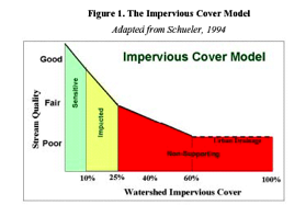
The main focus of GIS analysis for the DCC is impervious cover (IC). Because IC significantly degrades a stream and influences so many stream characteristic (http://www.cwp.org/runoff_rundown.htm), it has become a high priority. Incidentally, Secret Ravine is also the testing grounds for CalEPA, which is developing their own local IC model for Northern California. The DCC will then use their methodology to conduct their own study.

Why is IC so important, such a high priority? What are the stream characteristics heavily influenced by IC?
Probably the largest and most obvious contributing factor of IC is non-point source (NPS) pollution run-off, which "is now the leading threat to water quality." Streams of the Dry Creek watershed feed into our current drinking water source. In addition, "the surge in flow rate and volume in the receiving stream brings about an enlargement of bank-full and stream scour events and significantly influences the morphological structure" (http://erg.usgs.gov/tilley), which significantly degrades fish habitat. Run-off also increases surface water temperatures and reduces aquatic biodiversity.
"A large body of research consistently has found that impacts begin to occur even at very low levels of overall watershed imperviousness" (Schueler, 1994; Arnold and Gibbons, 1996). Thus many GIS layers are being acquired to perform a simple IC analysis using land use data at the parcel level. That is, the most cost effective way to measure IC as a percentage of landcover is by calculating the total landuse category and multiplying it by a coefficient that best matches the likely run-off for that landuse type (see appendix for examples).
The alternative would be to digitize all of the impervious surfaces over a vast area (a huge undertaking) or perhaps use remote sensing to detect IC (which is also expensive for an average city government). Why digitize a "vast area" rather than just lands adjacent to the stream? Remember urban storm water is often fed into a watershed system (via pipe works) great distances from an actual stream. Thus the IC analysis needs to consider lands that cover large areas, such as the entire city of Roseville.
So in summary, what thematic GIS layers are needed to analyze impervious cover (IC)? They are: landuse data, zoning (for more refined analysis), land cover, parcels, storm drain outlets (perhaps), stream data, flood plain data, and perhaps soils (see "Watershed thematic layers.doc").
And of course the GIS analysis will change with time, perhaps focusing on areas without pavement, such as dirt roads, or vegetation or areas of open space. GIS is just a tool to help you solve whatever problem seems to be of paramount importance and interest at that time.
Reading Index