Day 15 - Kenney Reservoir
to Pennsylvania Creek - 6 miles
 By
Sunday afternoon we are back on the trail. We have had just enough time off
to feel like beginners again, tiring easily but also feeling at home away from
worldly chaos. Our packs are lighter this time because we have learned what
to avoid: heavy binoculars, gators, an extra safety rope, and even a heavy Gortex
rain coat (instead I use a lighter rain coat and plastic garbage bags). Some
of this equipment was needed before, but most of it was a luxury. Still our
packw are heavy enough with two more weeks of food and essential gear.
By
Sunday afternoon we are back on the trail. We have had just enough time off
to feel like beginners again, tiring easily but also feeling at home away from
worldly chaos. Our packs are lighter this time because we have learned what
to avoid: heavy binoculars, gators, an extra safety rope, and even a heavy Gortex
rain coat (instead I use a lighter rain coat and plastic garbage bags). Some
of this equipment was needed before, but most of it was a luxury. Still our
packw are heavy enough with two more weeks of food and essential gear.
This country is much drier
than Yosemite. We are on the edge of the Sierra Nevada rainshadow where much
of the precipitation falls on the windward side (not on the leeward side that
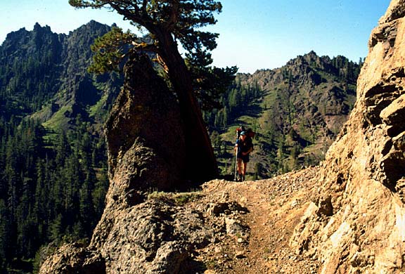
we are traversing). The trail cuts across volcanic formations and a profusion
of wildflowers complements the traill. After a couple of hours of rolling along,
we are ready to camp for the night. There is little water except for barren
creeks that intersect the trail occasionally. Camp is dusty with remnants of
other messy campers who have left behind a tattered pair of camouflage pants
and mangled cans. We go to bed early after a hearty meal. Tomorrow we will get
an early start to round the corner into the Blue Lakes region.
Day 16 - Rounding the
corner to Blue Lakes Area
Pennsylvania Creek to near
Tamarack Lake - 11 miles
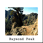
Today our goal is to round
the volcanic mountain (Raymond Peak - 10,000'), weaving in and out of volcanic
ravines and ultimately dropping into the Blue Lakes area. According to the map,
if we cut directly through the volcanic mountain to the west we could be there
shortly. Unfortunately no path exists, so we must loop around for several long
miles. As we reach the farthest point of the loop, we can clearly see down a
long valley to the small town of Markleeville. Most of the morning we spend
on the back side, but when we round the back side, we clearly see the "nipple,"
which stands out on our map and in our minds. Indeed the "nipple" is a prominent
beacon for the next two days until we leave the Mokelumne Wilderness.
By lunch we approach the
first lakes in a series of lakes easily accessible by automobile. In fact, automobile
accessibility is our first surprise as we approach a beautiful alpine lake graced
by a Toyota truck perched on its edge. We see more people, and think to ourselves,
apparently this is a popular point of entry with many dirt roads and vehicles
among the Blue Lakes region. Most of the day is spent traveling on level land
meandering through the woods and occasionally spotting a vehicle. We camp at
a place that we call the "granite ranch" because of the abundance of this rock.
Our camp is away from any lake and near a road, but it is open and peaceful
with numerous slabs of granite to set up a personal throne overlooking the "ranch."
By the way, the Blue Lakes are not directly on the trail. We soak up the afternoon
sun lazily for the remainder of the afternoon. By evening, we catch the last
of the sun light slanting through the trees. Later in the evening, a loud crash
rings through the brushes to startle us; we think, this could be a bear, but
most likely it is a noisy deer.
Day 17 - On the Road
Again
Tamarack Lakes area to Frog
Lake near Hwy. 88 - 10 miles
By early morning we ascend
to a barren ridge overlooking Blue Lakes. In the mountain silence a solitaire
fishing boat streaks across the Upper Blue Lake below. Gradually we crest the
rounded mountain and take a break. At this point we can peer down on the next
set of highland lakes, a real alpine jewel. We are astonished, however, that
another vehicle drives up to its shore before we reach it. This just does not
seem right to us--that we have walked all this way to a beautiful alpine lake
and someone else can just drive right up to it. In fact, if you look at a map
of the Mokelumne Wilderness you will see the boundaries allow for a bite taken
right out of the middle of it. This is where the main road goes, and unfortunately,
so does the PCT. What kind of wilderness has a tongue going right through the
middle of it? For those of you who really can't hike and prefer to drive, this
is the place for you. It is truly beautiful. By late afternoon we ascend out
of this drainage, cross over the western ridge and into Frog Lake. All around
us are snow-clad mountains, which I think to myself would be a great day-hike
or future overnight trip. That afternoon I gaze up at the puffy clouds and dream
of my childhood days. Peering over the edge, I see Hwy. 88 over Carson Pass
snaking its way through the level mountain meadows... the back way into Nevada.
Day 18 - Pioneer Days
Frog Lake to 1/2 mile past
Bryan Meadows (perched over S. Lake Tahoe) -12 miles
 This
morning is downhill briefly to meet Hwy. 88 where a historic marker is dedicated
to the famous mountain man, Kit Carson. In the old days this relatively low-lying
pass (about 8,000') was used to trek through the Sierra Nevada Mountains beneath
heavy snows. After crossing the highway we climb over a small saddle and into
a long trough filled with meadow and patches of trees. Within a half hour (of
Carson Pass) we see our first views of Lake Tahoe. The Upper Truckee River Basin
is lush, broad and open. As we travel another 1/2 hour more down the trail,
we spot a cabin tucked away behind a clump of trees. We notice some people saddling
a horse, which reminds me of the pioneers who must have used this same route
to reach Lake Tahoe. I can just imagine what a lovely sight Lake Tahoe must
have been for those weary pioneers who were bringing in their Conestoga wagon
from the arid prairie and high Nevada desert.
This
morning is downhill briefly to meet Hwy. 88 where a historic marker is dedicated
to the famous mountain man, Kit Carson. In the old days this relatively low-lying
pass (about 8,000') was used to trek through the Sierra Nevada Mountains beneath
heavy snows. After crossing the highway we climb over a small saddle and into
a long trough filled with meadow and patches of trees. Within a half hour (of
Carson Pass) we see our first views of Lake Tahoe. The Upper Truckee River Basin
is lush, broad and open. As we travel another 1/2 hour more down the trail,
we spot a cabin tucked away behind a clump of trees. We notice some people saddling
a horse, which reminds me of the pioneers who must have used this same route
to reach Lake Tahoe. I can just imagine what a lovely sight Lake Tahoe must
have been for those weary pioneers who were bringing in their Conestoga wagon
from the arid prairie and high Nevada desert.
We cross the meadow, trying
not to draw attention to ourselves, and continue toward Lake Tahoe on a fairly
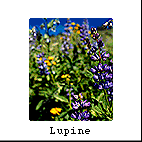
level keel. Within an hour, however, we veer left (west), pop up an incline
that is completely showered with fresh lupine, pass a small and secluded lake
(called Showers Lake) and then soon level out and head slightly down again toward
Lake Tahoe. We are now out of the Truckee Basin on an adjacent path. Much of
the country is open again with an occasional meadow and scraggly woods. There
are few people and no road running through this section of the PCT. The day
is pleasant day, and I think to myself how great this hike would be for an overnight
backpacking trip with a shuttle at the bottom of Interstate 50.
For lunch we regret that
we did not stock up on water because at Bryan Meadows clean water is less than
abundant; we have to skim water from stagnant bogs, filtered it (of course),
and fix some soup. It is not long afterwards that we set up camp on a perch
overlooking South Lake Tahoe. We see parts of South Lake Tahoe and hear cars
along a back country road. Below us we know is Echo Lake Resort and a post office,
which tomorrow is our pick-up point for supplies and the gateway into the Desolation
Wilderness. Yet we are pacing our rate of travel in order to stay on schedule
(i.e. we don't want to arrive too early before our pick-up date). So for now
we enjoy a fabulous sunset that illuminates the southern face of Lake Tahoe's
mountains rising high into the sky.
Day 19 - Crossing the
"Rubicon" (or threshold at Interstate 50)
1/2 mile past Bryan Meadows
to Susie Lake) - 13 miles
Perched over South Lake
Tahoe, we descend about 2 miles, pass a ski resort, and sneak across Interstate
50. We are like timid animals again in the eyes of automobiles but soon we work
our way past scattered cabins and rolling country until, in less than an hour,
we approach Echo Lakes Resort. Below us we see a loud refrigerated truck rumble
into the community area, which we suspect is there to stock the general store
with ice cream and fresh produce -- lots of it for us. We joyously buy supplies
and pick-up what we have mailed to ourselves a month earlier. We eat cereal
that is soaked in real milk and then board a boat (called "Why Walk"), which
will shuttle us another 3 miles across Echo lakes to the trailhead of the Desolation
Wilderness. This wilderness area, incidentally, is one of the most popular backpacking
destination in Northern California. We are grateful for the ride and immediately
disembark to head uphill. Looking down upon Echo lakes and the quaint cabins
that rim its shores, I can see why many people flock here. It is beautiful Sierra
scenery. Toward the west stands the majestic glaciated Crystal Mountain Range,
and to the north looms Dick's Pass (9380'), which tomorrow we will cross. But
our destination for today is Susie Lake several miles away. At least an hour
(or more) later, we skirt a rather large Aloha Lake (which is actually partly
dammed to impound more water for a thirsty Sacramento Valley below). Past the
lake my partner and I now ascend along a east-west, much narrower valley. It
is least another hour until we reach Susie Lake. With many others campers around
the lake, we fix our favorite meal, garden burgers and then wander ahead a bit.
Later we climb a small ridge behind our camp to watch the Crystal Range and
Pyramid Peak glow in the sunset.
Day 20 - In the Heart
of Desolation Wilderness
Susie Lake to Middle Velma
Lake - 7 miles
Today we rise early to embrace
many switch-back on our way to the saddle at Dick's Pass. Along the way we encounter
an array of purple lupine and red Indian paintbrush; the scenery is straight
out of movie, particularly "The Sound of Music," which my partner and celebrate
with swirling dance. The backdrop is spectacular with distant views of Lake
Aloha and the Crystal Range behind it. Snow still lies in the shadowy bowl of
Half Moon Lake directly below us, and within a couple hours we are looking directly
down upon the other side of the Tahoe / Desolation basin. These are the best
views we have seen since Leavitt Pass (Near Sonora Pass) and we won't get these
lofty views until we reach the back side of the Squaw Valley ski resort area
(Granite Chief Wilderness). I review the geography from the past several days
of travel -- clear back to the Upper Truckee River basin, and then I look ahead
of us for the next couple of days including Velma Lakes below. Before long we
descend to Dick's Lake in the bowl directly below us and proceed for another
hour or so to Middle Velma Lake. By noon we set up camp and relax for the rest
of the day. Middle Velma is large enough lake to accommodate many campers who
pour into this area for the weekend. By the afternoon the wind whips us, so
we lash down the tent for the evening. As dark falls, the flickering fires around
the lake remind me of a Walt Whitman Civil War poem - By the Bivouac's Fitful
Flame..."the tents of the sleeping army, the fields' and the woods' dim outline,
The darkness lit by spots of kindled fire..."
Day 21- Middle Velma
Lake to near Barker Pass - 10 miles
Leaving Velma Lakes is easy
and relatively flat. You head inland (away from Lake Tahoe) down a long, glaciated
trough filled in with trees and wilderness. We don't see many people and by
late morning our odyssey leads us out of the official wilderness area into mixed-use
areas, such as off-road vehicles (ORVs), shooting ranges, and ugly clear-cut
forests near Barker Pass. We find a meadow near a dirt road and set up camp.
The only nearby lake is (automobile accessible) Richardson Lake, which we decide
to pass because it is crowed. Today was a mostly level, easy hike.
Day 22 - Crossing Barker
Pass in ORV Land
Near Barker Pass to Blackwood
Creek - 5 miles
It is surprising to note
the differences between Yosemite and the Tahoe area, such as fewer mosquitoes
but more noise and people. The Tahoe area now seems more accessible by motor
vehicles and more impacted. Logging large trees takes place right off of the
PCT. At Barker Pass we appreciate a wooden picnic table and benches for a mid-morning
break of cereal. We also talk to another hiker there who is loaded to the gills
with gear such as a ham radio, a big flashlight, knife, a gun, lots of food
and is dressed in black combat boots. A black dog follows behind him and both
of them turn out to be friendly. After Barker Pass (a Forest Service dirt road),
the trail traverses up a small ridge to provide another excellent view of Lake
Tahoe and the volcanic landscape rimming this northwestern side of the Tahoe
Basin. The trail roughly follows a contour along these ridges. But we don't
go very far. Within 5 miles we reach camp, and again, we could have hike much
farther this day, but we are ahead of schedule and must now partake in a layover.
Day 23 - Layover
Bored but have good views
of Lake Tahoe - 0 miles
Day 24 - Resting Behind
Squaw Valley
Blackwood Creek to Headwaters
of the American River (middle fork) - 13 miles
This morning we must been
wound up and ready to go, because by 6:30 we are on the trail and traversing
up a steep ridgelines that cups the northwest part of the giant Lake Tahoe basin.
Tough basalt and lava rock hold the ridges shape well. Soon we can see a prominent
landmark, Twin Peaks, a remnant of volcanic activity. By the time we reach this
point, we can see all the way back to Dick's Pass and beyond. Classic PCT views
prevail as we see both sides of the Sierra-Nevada crest. We are on a fairly
level keel along the ridge this early morning with views of Alpine Meadows Ski
resort below. Unfortunately our luck runs out because we are not allowed to
stay on this prominent ridgeline for long. Soon we descend to the Five Lakes
area below and into the Granite Chief Wilderness proper. Going down means going
up later. By noon we are navigating up the Whiskey Creek drainage with little
or no water. The volcanic soil is very porous and dry here. But by lunch time
we have traveled a fun 10 mile stretch with lots of views, and somehow we find
water to make our daily soup. Within an hour and a half we reach the Middle
Fork of the American River, a nice little creek among lush grass and flowers.
It is a pleasure to splash around and clean our stinky bodies here. Some day
hikers appear next to the backside of a ski lift, apparently riding the Squaw
Valley Tram and hiking toward the crest. So we know civilization is close by.
Most of this day we see evidence of ski resort signs conveying phrases like
"out of boundary" and strewn like a picket fence along the crest. Day hikers
stumble by us again as I stare onto the vast mountain ranges and canyons fanned
out below. A purple haze fills the sky as we eat dinner and settle in for the
evening. Tomorrow is our last day, but we know it is a long one.
Day 25 - Our Last Day!
Headwaters of the American
River (middle fork) to Soda Springs - 17 miles
This morning is fresh and
exciting for us because we are on our way home! Still, we have 17 more miles
to go. I step over the Middle Fork one more time, which I suppose symbolized
crossing over the finish line toward home.
Within a half an hour we
surmount a steep ridgeline that overlooks the upper lodge of Squaw Valley ski
resort. We enjoy panoramic views of Lake Tahoe again in the background, but
in between us, strangely, rises a giant bungee jumping apparatus at the Squaw
Valley upper lodge.
An angry grouse startles
us as we work our way below the silent ski lifts. I look up and remember standing
here as a kid with snow all over this hillside and skies strapped to my feet.
But now everything looks totally different, including the bungee jumping apparatus.
The trail continues over and around a ridge into the North Fork of the American
River. Soon we drop into another hidden canyon away from the expansive views
of Lake Tahoe. Within an hour, we cross its headwaters, which is but a small
rivulet running through green meadows and wildflowers. Yet below us I can see
a deep, dark canyon and imagine the raging rapids that run through it. I know,
in fact, that the forks of the American river offer some of the best white-water
in the country.
After resting at the North
Fork of the American, I find a few camping spots tucked away by the trees. Immediately
we are climbing again out of this drainage. Our guidebook seems to gloss over
this elevation gain, which we have encountered so many times before. Within
an hour and a half, however, we are on top of Tinkerbell knob looking down again
on the hazy Truckee valley and the Lake Tahoe basin. It is nearly a panoramic
view again. I can spot Northstar ski area to the east and even Interstate 80
heading toward Reno. We round Tinkerbell Knob and see our tawny trail heading
straight down a barren ridgeline like the yellow brick road leading us home.
We think to ourselves, if only we had wheels, then we could coast all the way
down this path within a matter of minutes. But it is quite a few hours until
we reach the bottom.
Eventually we see a few
day hikers. This is a sure sign that we are getting close to the trailhead.
Near the top of Sugar Bowl ski resort, we find a historical marker honoring
the Donnor Party that passed through this saddle nearly 150 years ago (under
quite different conditions). What a touching moment this is for me because I
now know how rugged these mountains are, especially in the winter time. In twenty
minutes we spot ski towers and a broad swath of cleared forest to make room
for another ski run. The day hiker count increases and finally we see Norden
Meadows -- a supreme moment and our "manifest destiny." It is hard to believe
that in about a half an hour of switchbacks, we will descend onto a paved parking
lot and reach civilization at last.
When we arrive, there is
a busy and chaotic buzz about the place and we still have three more long miles
to go to Soda Springs. Along the way, a crew of foresters busily harvests the
forest and makes more noise than we have heard in a month. The incessant buzz
of combustible engines fills the air, and to me, this is the hallmark of "civilization"
-- combustible engine noise. Down the road I rest on a stump because my feet
are seriously aching after 15 miles of hiking (and it is only 1:00 p.m.). Some
sheep bleat in the background and, little do we know, this is where we are going
to spend the night. Tomorrow our friend is going to pick us up in the small
hamlet ahead. The Soda Springs general store soon emerges like an oasis in the
desert. We are done by 2:00 p.m. and decide to eat a fresh sandwiches instead
of dehydrated soup.
Across the way is the "Little
Stinker Cafe," which we choose as our first celebratory meal for dinner. It's
"happy hour" and we order a pitcher of beer, a fresh salad and a pizza. The
waitress snaps our picture and we reflect upon how easy this trip really was...
yet I know that we always seem to downplay how hard it really was--all of those
hard uphill hikes, all of those joint pounding down hauls, the blisters and
aches, those annoying bugs, our meager lunches, and those long days and lack
of entertainment. Still we are finished. Step by step we made our way across
a vast distance that seemed unfathomable just a month earlier. Now that we are
finished, we are ready for more backpacking tomorrow, but we know that we won't
be back here in a long time. It just seems so easy to do this trip all over
again. Try it yourself.
 By
Sunday afternoon we are back on the trail. We have had just enough time off
to feel like beginners again, tiring easily but also feeling at home away from
worldly chaos. Our packs are lighter this time because we have learned what
to avoid: heavy binoculars, gators, an extra safety rope, and even a heavy Gortex
rain coat (instead I use a lighter rain coat and plastic garbage bags). Some
of this equipment was needed before, but most of it was a luxury. Still our
packw are heavy enough with two more weeks of food and essential gear.
By
Sunday afternoon we are back on the trail. We have had just enough time off
to feel like beginners again, tiring easily but also feeling at home away from
worldly chaos. Our packs are lighter this time because we have learned what
to avoid: heavy binoculars, gators, an extra safety rope, and even a heavy Gortex
rain coat (instead I use a lighter rain coat and plastic garbage bags). Some
of this equipment was needed before, but most of it was a luxury. Still our
packw are heavy enough with two more weeks of food and essential gear.